


Alto Camp, Arizona. A 4x4 Experience.
Back to our VisitTubac.com home page.
by Richard A. Zidonis
WebZar.com, Inc. Contact Rich
 The Ghost Town of Alto Camp falls squarely into the "you can't get there from here" category, or maybe I should say you
shouldn't get there from here... here being the Amado side of the Santa Rita Mountains.
The Ghost Town of Alto Camp falls squarely into the "you can't get there from here" category, or maybe I should say you
shouldn't get there from here... here being the Amado side of the Santa Rita Mountains.
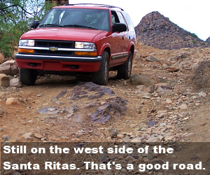
We did manage to survive the impromptu trip safely, although not without the element of fear and death. I'm guessing, here, but I think I probably would have had a pretty decent story to tell St. Peter had my Chevrolet Blazer 4x4 rolled over the shelf with me in it. Once we arrived at finding ourselves with three wheels on the road and one wheel more or less thinking itself an anti-social who was not willing to play nice.... Well, I drove the fourth tire back onto the road, but only because of the process used. It is probably telling enough to say that my new nickname is Short Straw.
I say "over the shelf" because of the descriptive language used on off-roading websites. Different sites use the same, exact understatement. They must borrow liberally from each other.
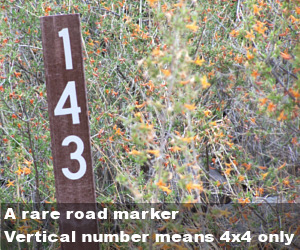
Of course, we were not truly off-roading. We were collecting meteorites. A hot tip on the location of a meteorite field found us jaunting down Bull Springs Road, AKA Forest Road 143, a side trail off Mt. Hopkins Road near Amado, Arizona. We immediately needed our 4-wheel drive to negotiate a sandy and steep arroyo. Down we went. Up we went. In Spanish that is no problema. In Terminator talk, it's no problemo.
Well, we recovered about 200 pounds of meteorites. Turns out, we collected about 200 pounds of hematite. But I digress.
With the meteorite/hematite collection completed, someone said "let's see where this road takes us." Our Forest Service Map showed that it twisted and turned its way to Alto Camp. Hey, why not? Let's do it.
 Here's an excerpt from one of the off-roading websites:
Bull Springs Road: little-used mining road crosses Santa Rita Mountains from Interstate 19 to Hwy. 82 south of Patagonia. See mines along the route and adobe ruins at Alto Camp, once a community of several hundred people. The post office was active until 1933. Narrow, rocky shelf road at higher elevations. Suitable for high clearance stock SUVs. Remote location.Here's a valuable note: you really want to read stuff like this before the trip, not after.
That web site must have had space constraints. My off-roading site - if I had one, would have no such constraints. On my site, I would choose to expand the passage. First, I would start with "little used mining road."
My off-roading site would say: "This path through the mountains was last used in 1860 by a miner who took a wrong turn at Tubac." I would continue, "Having never been on the so-called road, the Forest Service assigned this trail a route number via satellite surveillance."
Continuing on with my expanded information, instead of "narrow, rocky shelf road at higher elevations," I would write: "The comfortable, two-lane dirt road that you have been traveling on for an hour now is about to turn into a one-lane road that will pretty much head straight up the Santa Rita Mountains to become not quite a one-lane, rock-strewn ledge carved out of the face of the mountain on which you will not be able to open the driver's door and where you will not want to open the passenger door."
Sidenote: you know, the "pro" thing about "higher elevations" is that they offer tremendous views. The "con" thing is that they offer tremendous falls. Couple that observation with the previously mentioned anti-social tire and you have yourself a real thriller.
Next I would tackle "see mines along the route." Yes, we saw mines. I love mines. The trip was probably worth the mines, but, gosh... how can anyone neglect to mention the bullet riddled car carcasses? I think the words "and bullet riddled car carcasses" need to be added to the descriptor on each of the 4x4 websites. Instead of stars or colors codes, car carcasses could be the rating system. Each 4x4 trip could display the degree of difficulty by a car carcass count. Let me be the first. I'll add the CCC to my expanded description:
 "The Amado-Bull Springs-Alto 4x4 trail is rated at three car carcasses." I can only surmise that the car carcasses
stood where they stopped. Putting them out of their misery was the right thing to do.
"The Amado-Bull Springs-Alto 4x4 trail is rated at three car carcasses." I can only surmise that the car carcasses
stood where they stopped. Putting them out of their misery was the right thing to do.
Then the final comment about the standard description involve these two words: "Remote location."
I think I saw an Apache. Then there was that faded sign that said "Spaniards for Arizuma."
Well, to be anti-climatic about the whole thing, I already mentioned that Mr. Short Straw coaxed the recalcitrant tire back onto the road and we collectively survived. I know. Boring.
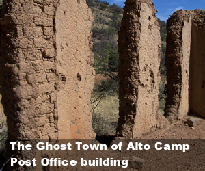
Suddenly, there it was... The Ghost Town of Alto Camp, the home of the first female postmaster (postmistress?) of the United States of America.
One day while traveling on horseback to visit a neighbor, Minnie Bond and her horse were killed by a bolt of lighting. Her baby daughter, Catherine, snuggly wrapped in a blanket on the same horse, survived. On another horse was her son Albert, who also survived, her husband was grief sticken, and the son was traumatized to the point of speechlessness, but that's a story for another day.
Epilogue: Alto Camp is most easily approached from the east via Patagonia. From Route 82, look for Blue Haven Road, which connects with Salero Ranch Road, which is also known as Forest Service Road 143 (get a Forest Service Road map from the Ranger Station near Ruby Road and I-19). Ten bucks last time I checked.
 Continue on 143 for about 15 miles (that's a guess). Although dirty, dusty and washboarded, the road is usable
by passenger cars until the last mile or two (another guess). From that point on a high clearance vehicle is needed.
Continue on 143 for about 15 miles (that's a guess). Although dirty, dusty and washboarded, the road is usable
by passenger cars until the last mile or two (another guess). From that point on a high clearance vehicle is needed.
From Amado in the west, travel with a minimum of two vehicles, one of which should have a winch (boy... could I have used that advice). I would also take food, water, tools, jacks, a two-way radio, and a firearm or two.
Questions? Write. I would be happy to hear from you.
Here's a map link showing Alto: Show Me
Here's the Patagonia starting point: Show Me
Here's the Amado starting point: Show Me
Alto Camp is also accessible via privately owned Salero Ranch.